Lonely Road
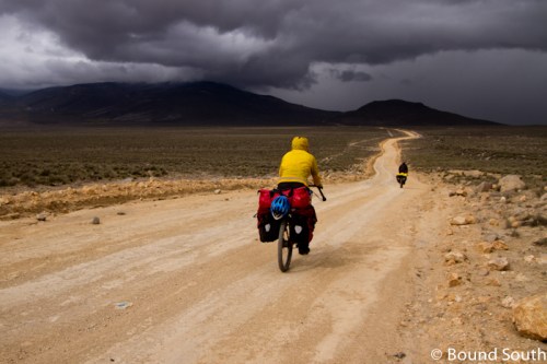
When_we_look at a map it is natural to see the highlights. Bigger cities get bigger names on the page. Country borders rise up to delineate an otherwise unbroken horizon. To see great cities by bicycle and to check another country off of our list is a tremendous thrill. Yet often the best riding in life is unexpected, and the most exciting roads are those that have no names and no signs and few people. Just a few days from Chile in the Peruvian city of Arequipa, we set out on some lonely roads to Lago Salinas and beyond. It felt like a ride around another world.

Climbing away from Arequipa, Volcano Misti in the background

Looking back at our road through the clouds

Dreamscapes

We found respite from the hail and rain in this tunnel.

Lakeside exhaustion
We climbed from the moment we left Arequipa and didn’t stop till we found winter. Starting in the hot sun at 7600 ft, we climbed a grueling dirt road for a day and a half until we arrived at Lago Salinas, a mountain-stream-fed lagoon in an eternally frigid, windy, Peruvian drizzle that can only be found above 13,500 ft. The road was deserted and alternatively bumpy, sandy, muddy, or inundated with water at the top. We were hungry and under-prepared. We arrived to a small cluster of buildings on the southeast corner of the lake, a small pueblito known as Moche before nightfall. There was a single small tienda run out of the front room of a woman’s home. No simple restaurant or hostel existed, and the prospect of tenting in rain and sub-freezing temperatures was disheartening. I had had one of the worst days of my life on the bike, bonking in the cold and struggling to turn the pedals over for the last few hours of the ride. We begged for the storeowner’s help, and in short time we had a place to stay in the spare room of her friend’s home, as well as hot plates of rice, eggs, and potatoes.

Mountain sunset from Moche

Our ribbon of road over the tundra

Snow blanketed our path over this 15,000 ft. pass

Thick mud and a lake of water forced us up and around the adjacent hill in this section.

Patching a pinch flat on the descent from Lago Salinas - moss covered rocks for seating
We hardly slept due to altitude sickness. Piercing headaches kept us up unwillingly while we craved the sleep we needed to recover and heal from the past day of riding. We were in the middle of nowhere, and despite our tremendous blessings and good fortune, we felt very alone and somewhat daunted. The next morning we woke to snow. Pressing on that next day we took the old road south of the lake, determined to descend out of the high altitude Peruvian winter we had stumbled upon at Lago Salinas. “Road” is such a strong word sometimes. Perhaps “trail” or “pathetic vestige of mistaken vehicular activity” would have been more appropriate on this occasion. We struggled to climb the sandy path that slowed our wheels to walking pace. At times the road would simply disappear or become submerged under a lake or stream. This gave us the rather fun opportunity to simply ride out into the tundra-like snow and rock fields at nearly 15,000 feet of elevation and make our own trail. We are confident that vehicles do not pass that way for days at a time. It’s entirely likely that if the rain and snow were to stop, our tire tracks would be there waiting for the next set of bicycle adventurers to find.

Climbing once again, from Puquina this time

Terraced fields covered the valley floors and walls near Puquina; years of incredible physical labor were visible here.

Cliffside roads became the norm.

So did sweeping descents.

And sand.
It’s tremendously humbling to struggle all day against slow, sandy roads and steep climbs and only manage a walking-pace accomplishment of fifty kilometers. It can be disheartening to ride through empty places with no towns or tiendas to buy a simple Coke and sit in the shade to rest. These lonely places don’t have names or even the recognition of existence on Google Maps. This is flyover country, the space between where travelers find themselves and where they’d like to be. We relish that solitude, the intoxicating sense that we might be one of the few people to ride a bike here, ever. And though we might only see a handful of people, our interactions with them are that much more meaningful. Simply seeing another face on these roads is reassuring; for the Peruvians who see gringos riding these terrible, random, Andean dirt roads…we must be terribly peculiar. We descended goat paths out of the wintry mountains and after braving some tooth-rattling descents into the desert valleys below, began our many sandy, steep mountain passes on the road to Moquegua. We ran out of water and discovered that in over a hundred kilometers of consecutive 4000+ meter passes, there are no towns and we were lucky to see three vehicles…and even more lucky when those vehicles donated their half-consumed bottles of Inca-Kola and bags of bread to us so we could survive.

Down to the desert canyon

Roadside donations.

Climbing out of the canyon

Looking back at our road on the canyon floor.

Late afternoon shadows.

No water or food meant a hitch with a couple guys and their fruit truck to the nearest town.
Now we leave Peru and all its goodness behind us. As you read this, we’ll be setting our tires on Chilean soil for the first time. The finish in Ushuaia has never seemed closer. Yet for all of the highlights ahead and behind us, our minds still flock to the solitude of the empty, unremarkable, and yet still extraordinary worlds we are privileged to explore by bicycle.


Oh, my! I can only imagine what it must be like to be your mother. Your adventures certainly give new meaning to “Trust in the Lord with all your heart. In all your ways acknowledge Him, and He will direct your paths.”
Okay – this is the type of post which makes me want to get on the nearest airplane – swoop down – and take you back to ND – or even to NJ. Thank God for those who helped in your time of need.
This is the type of post which makes me want to get on the nearest airplane – swoop down – and join you.
How long is this trip – how many miles,km do you ride a day.
ENJOY!\!
Wow – awesome photos and blog guys. We devour each one of your posts and they always leave us excited for the road ahead…
James & Sarah – currently riding with Lee Saville in San Cristobal, Mexico
How do you pick the roads to travel on? Were all the roads mapped out in advance? Do you use maps found in each specific country? Is it by word of mouth from locals? Previous cyclists? Do you use GPS at all? Interested in the path of your journey….Matt
Hey Matt, we use a combination of Google Maps, local advice, and various online resources (lonely planet, travel websites, other touring cyclist blogs, etc.). We carried maps in Mexico, but rarely do anymore. Typically, we map out a week of riding on Google Maps, save it as an image, and write down major towns and waypoints on the route. We don’t use GPS, and our simple bike computer failed in the United States. Sometimes Google Maps routes over nonexistent roads and locals give us poor directions, so It isn’t a perfect method for routing.
You guys are amazing! I worked at between 3700 and 5000m in Tibet for two years and understand how bodies work (or do not work) at those elevations. Cycling up and over passes at those elevations would be the ultimate test of your will to carry on; and how you have adapted. I have been following your blog since you were in the Columbia Valley in BC and enjoy the writing and photos of the landscape and people and food so much. What a great way to spend a year; wish I was younger. I will have to do some travel in S. America. With your sense of adventure you must be in our Berg family tree somewhere.
Continue to hold you in our hearts on this amazing journey. May you be kept safe as you travel through Chile.
Wow, what a great post! I am certain you will find even more solitude and lonely roads on Patagonia. No where’s land with a lot of wind! Be ready for another adventure!
We give thanks to the Lord for providing help in your time of need. We believe blessings will come back 100 fold to the lady who helped you and to the driver of the fruit and vegetable truck. It would have been easy to say No to Gringos…but they did not.
You looked so good last night on Skype! Keep pressing on…farming is around the corner here and there are rocks to pick and fields to seed. Keep connected with us and with each other knowing that “In all your ways acknowledge Him and He will direct your paths.”
Mom, Dad, Marta and Grandpa Overvold
WOW! Beautiful and treacherous at the same tie. The Lord was watching the three of you through this stretch of ROAD???? Great pictures and memories of the accomplishment.
Take care!
Incredible shots guys! Can’t imagine what that must be like to experience firsthand. Good work on making it to Chile… you’re almost there!
Amazing journey, and beautiful photos. Drive carefully….!
The pictures are wonderful..I can’t imagine the turmoil you have been going through.. Bless the help you have been given along the way. Keep on biking and I’m sure all will be ok in the time you have left for your trip..You’ll be coming home in time for the graduation of your sister.. Blessings to you!!
The worst is no doubt behind you. The Atacama, as harsh as it can be, is much easier this time of year than any place in Bolivia. You will love Santiago and Mendoza.
I’ve been following your posts (mostly) since you guys left Alaska. I enjoy your writing and the pictures have been awesome. You guys make me wish I was young (and adventurous). But particularly, instead of simply being a “silent watcher,” I wanted to send a kudos for what you guys are doing.
What incredibly wonderful experiences you are having! And what wonderful poetically meaningful statements you make! And we are totally grateful about all the gifts God is sharing with you (and therefore, you share with us). Your last sentence is one of those powerful statements that we can all take with us everywhere. The rest of us are riding beside you, and learning from you, and planning for our own “treks” because of your inspiration! God is with you!